
What Are Geofencing Restrictions In Drones?
Understanding Geofencing Restrictions in Drones
If you’re a drone pilot or considering purchasing a drone, it’s essential to understand geofencing restrictions. Geofencing is a virtual boundary that can be set up around a specific location. In the case of drones, geofencing is used to restrict where drones can fly in order to ensure safety and compliance with regulations. In this article, we will delve into what geofencing restrictions are in drones and how they work.
What is Geofencing?
Before we get into geofencing restrictions in drones, it’s important to understand what geofencing is. Geofencing is a technology that uses GPS or RFID to define geographic boundaries. These boundaries can then trigger an action when a device enters or leaves a specific area. Geofencing is commonly used in various industries, such as marketing, fleet management, and now, in the world of drones.
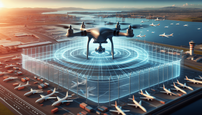
Geofencing allows drone manufacturers and regulatory authorities to set up virtual boundaries around certain locations, such as airports, military bases, and other restricted areas. When a drone equipped with geofencing technology approaches these boundaries, it will either be prevented from entering the restricted area altogether or forced to abide by certain height and speed limitations.
How Do Geofencing Restrictions Work in Drones?
Now that you have a better understanding of what geofencing is, let’s take a closer look at how geofencing restrictions work in drones. Drones that are equipped with geofencing technology rely on GPS coordinates to determine their location in real-time. When a drone approaches a geofenced area, the software on the drone communicates with the geofencing system to determine whether the drone is allowed to enter the restricted zone.
If the drone is not allowed to enter the restricted area, the geofencing system will either prevent the drone from entering the area entirely or enforce restrictions on the drone’s flight. For example, the drone may be forced to fly at a lower altitude, reduce its speed, or even return to its takeoff point. These restrictions are put in place to ensure the safety of other aircraft, people on the ground, and sensitive areas.
Who Sets Geofencing Restrictions for Drones?
Geofencing restrictions for drones are typically set by regulatory authorities, drone manufacturers, and third-party software providers. Regulatory authorities, such as the Federal Aviation Administration (FAA) in the United States or the Civil Aviation Authority (CAA) in the United Kingdom, establish no-fly zones and other restricted areas where drones are not allowed to fly.
Drone manufacturers also play a role in setting geofencing restrictions for their drones. Many drone manufacturers have partnered with geofencing software providers to ensure that their drones comply with local regulations. These partnerships allow drone manufacturers to update geofencing databases in real-time to reflect changes in regulations or temporary flight restrictions.
Third-party software providers also offer geofencing solutions for drone pilots who want to add an extra layer of safety to their flights. These software providers typically offer more advanced geofencing features, such as customizable geofenced areas, real-time alerts, and the ability to override geofencing restrictions in certain situations.
Examples of Geofencing Restrictions for Drones
To give you a better idea of how geofencing restrictions work in drones, let’s look at some common examples of geofenced areas and restrictions:
-
Airport No-Fly Zones: One of the most common geofencing restrictions for drones is around airports. Drones are not allowed to fly within a certain radius of an airport to avoid interfering with manned aircraft taking off and landing.
-
Military Bases and Government Facilities: Drones are also restricted from flying near military bases, government facilities, and other sensitive areas. These geofenced areas are put in place to protect national security and prevent unauthorized surveillance.
-
National Parks and Wildlife Refuges: Many national parks and wildlife refuges have restrictions on where drones can fly to protect the environment and wildlife. Drones are typically not allowed to fly over certain areas or disturb wildlife in these protected areas.
-
Public Events and Crowded Areas: Geofencing restrictions may also be put in place around public events, sports stadiums, or crowded areas to prevent drones from causing a safety hazard or invading people’s privacy.
How to Stay Compliant with Geofencing Restrictions
To ensure that you are compliant with geofencing restrictions when flying your drone, follow these tips:
-
Keep Your Drone’s Firmware Updated: Make sure that your drone’s firmware is up to date to ensure that it has the latest geofencing data and restrictions.
-
Use Approved Apps and Software: When planning your drone flights, use approved drone apps or software that provide up-to-date geofencing information and alerts.
-
Check for Temporary Flight Restrictions: Before flying your drone, check for any temporary flight restrictions in your area that may affect your flight plans.
-
Obey No-Fly Zones: Always respect no-fly zones and other geofenced areas to avoid fines, penalties, or even criminal charges.
-
Stay Informed: Stay informed about local regulations, no-fly zones, and geofencing restrictions in your area by regularly checking for updates from regulatory authorities and drone manufacturers.
The Future of Geofencing Technology in Drones
Geofencing technology in drones is constantly evolving to meet the increasing demands of the drone industry and regulatory authorities. As the number of drones in the sky continues to rise, geofencing will play a crucial role in ensuring that drones can coexist safely with manned aircraft, people on the ground, and sensitive areas.
One of the future developments in geofencing technology for drones is the incorporation of artificial intelligence (AI) and machine learning algorithms. These advanced technologies will enable drones to make more informed decisions when approaching geofenced areas and adapt their flight behavior in real-time based on environmental factors, traffic conditions, and other variables.
Another future trend in geofencing technology is the use of blockchain technology to create decentralized geofencing systems. Blockchain technology can provide a secure and transparent way to manage geofencing data and restrictions, ensuring that all stakeholders have access to accurate and up-to-date information.
Overall, geofencing restrictions in drones are here to stay, and drone pilots must be aware of and compliant with these restrictions to ensure the safety of their flights and the public. By understanding how geofencing works, who sets geofencing restrictions, and how to stay compliant, drone pilots can enjoy flying their drones responsibly and safely.